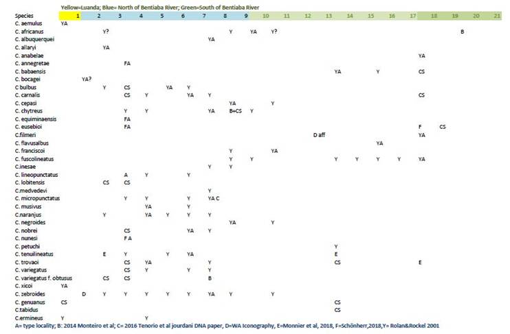
Distribution of Angolan Cones
In 2001, Rolán & Röckel published a spreadsheet showing the distribution of each species within the many bays on the coastline. The spreadsheet is arranged with columns 1-21 proceeding from the north to the south of the country,
This 2019 update continues their conservative approach. Updates are limited to published findings and specimens which are of the typical form. The publications are coded and listed at the bottom of the spreadsheet. In addition, localities where typical forms have been collected personally by Chris Schönherr are indicated by CS. Type localities are indicated with letter A.
Rolán & Röckel proposed that outflow of the Bentiaba River would act as a barrier to diversification and the spreadsheet reflects that boundary in the colour at the top of the columns.
A copy of the spreadsheet in Excel form can be found here Excel version.

Table 1. Distribution of
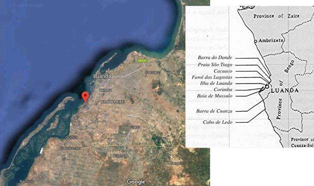
the known species of endemic Conus in Angola. 1: Luanda area (Praia
Santiago, Cacuaco, Corimba, Farol das Lagostas, Baja de Mussulo, Barra de
Cuanza).; 2: Lobito; 3: Benguela (Sombreiro, Caotinha, Caota, Baja Azul, Baia
Farta); 4: Cuoi, Baia de Equimina, Ponta Campeona, Baia dos Elefantes, Piambo;
5: Baia dos Limagens; 6: Baia do Binga; 7: Meva, Baia do Canoco, Baia de Santa
Maria; 8: Bonfim, Baia da Bissonga, Baia da Lucira, Baia do Cesar, Doca,
Capato, Calonga.; 9: São Nicolau, Bentiaba; 10: Baia das Salinas; 11: Chapeu
Armado; 12: Calungo; 13: Piambo; 14: Baia do Baba; 15: Baia do Mocuoi; 16: Baia
das Pipas; 17: Charungo, Praia das Conchas; 18: Baia do Saco Mar (do Saco),
Baia de Moçamedes, Ponta de Noronha, Praia Amelia,; 19: Ensenada dos Tres
Irmäos; 20: Pinda, Porto Alexandre, Ponta Albina; 21: Baia dos Tigres.
Page Last
updated 3 June 2019.